Raj Ghat, Delhi, is the open-air memorial marking the spot where Mahatma Gandhi was cremated in 1948. It is a place of deep national significance, dedicated to the memory of India’s great freedom fighter—the simple memorial honors the Mahatma’s life and ideals in a serene setting. A black marble platform sits at the center, with an eternal flame burning nearby day and night. The surrounding gardens, filled with flowerbeds and shade trees, add to the calm and solemn atmosphere.
This quiet park on the Yamuna River’s edge has become a pilgrimage site. Leaders and visitors from India and worldwide often come here to pay respects. On Gandhi’s birthday (October 2) and the anniversary of his death (January 30), special ceremonies with flowers and candles are held here. For any traveler interested in India’s history and culture, Raj Ghat is a symbolic place that tells a powerful story. It reminds visitors of Gandhi’s message of peace and unity in a heartfelt way. It has become a symbol of national unity for many Indians. Thousands of people – locals and visitors from abroad – come to Raj Ghat to pay their respects to the Mahatma each year.
Historical Significance
Mahatma Gandhi, often called the “Father of the Nation,” led India’s non-violent struggle for independence from British rule. He organized peaceful protests and movements that inspired millions of Indians to join the cause. Events like the 1930 Salt March against the British salt tax and the 1942 Quit India movement were key moments in the fight for freedom. Gandhi’s ideas of non-violence and truth won respect around the world. 1947 India finally achieved independence, and Gandhi’s leadership was a big part of that success.
Gandhi’s ideas of non-violence and unity were fundamental during the tense months around the Partition in 1947. Even after independence, he traveled to promote peace between Hindus and Muslims. Earlier in 1948, Gandhi had briefly fasted to calm communal violence after Partition. After independence, he chose not to take political office, preferring to live simply among the people. His assassination on 30 January 1948 was thus especially shattering, occurring at a time when India was still healing.
On that day in January, Gandhi’s life was cut short by an assassin’s bullet in New Delhi. The news stunned the nation and left millions of Indians in mourning. The very next day, 31 January 1948, Gandhi’s body was carried to the banks of the Yamuna River in a massive funeral procession through the city. At sunset, he was cremated at this spot now known as Raj Ghat. The black marble platform of Raj Ghat marks exactly where the pyre was lit. Because many people witnessed Gandhi’s final rites, the place became hallowed ground overnight. It made Raj Ghat an even more poignant symbol of unity and peace.
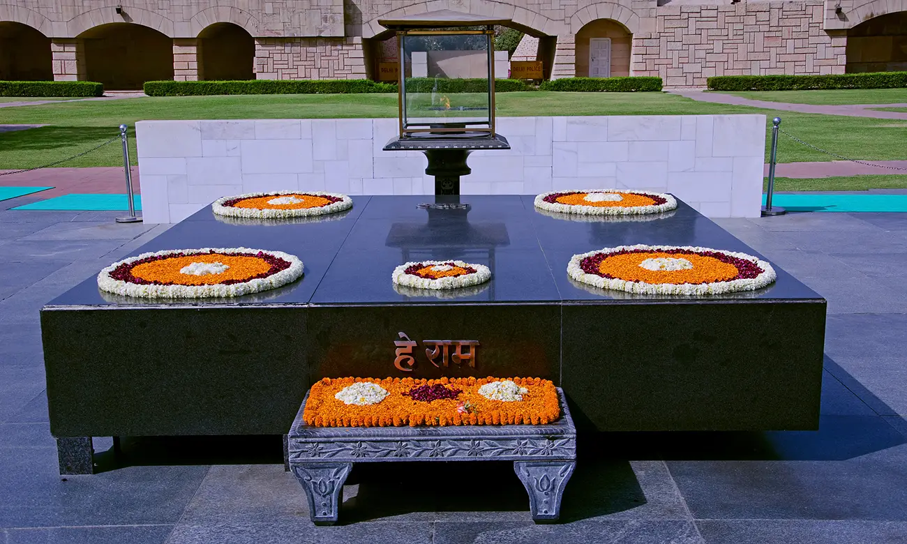
After that day, the Indian government turned Raj Ghat into a permanent memorial to Gandhi. A black marble platform was built on the exact spot of the cremation. The words “He Ram” were engraved on the stone, which is believed to be Gandhi’s final utterance as he died (the phrase means “Oh Lord” in Hindi). Since then, Raj Ghat has been preserved to honor Gandhi’s memory and sacrifice. Every year on January 30th, government leaders and citizens gather at Raj Ghat to light candles and remember his teachings. It has become a timeless reminder of his message.
Memorial Description
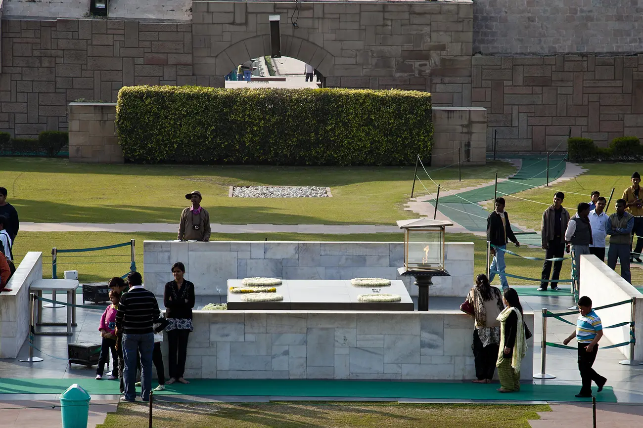
At the heart of Raj Ghat is a simple black marble platform. The square slab is slightly raised above the ground and bears the engraved words “He Ram,” believed to be Gandhi’s final utterance. An eternal flame in a bronze lantern burns at one end of the platform, symbolizing Gandhi’s legacy. The area around the platform is open to the sky and is enclosed by low boundary walls.
The original memorial design was completed in 1956 by architect Vanu G. Bhuta following a national competition. The design’s simplicity – a clean, square layout with no statues or elaborate decorations – was chosen to reflect Gandhi’s minimalist lifestyle. There are no statues or pictures here – only the empty sky above the marble slab. Visitors often leave flowers at the base of the platform. Bright marigold blossoms and garlands are popular offerings. The platform may be covered entirely in marigold petals on special occasions, creating a colorful carpet of flowers around the flame.
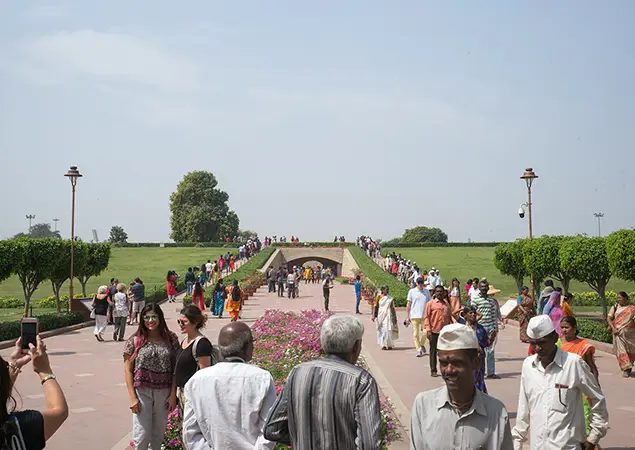
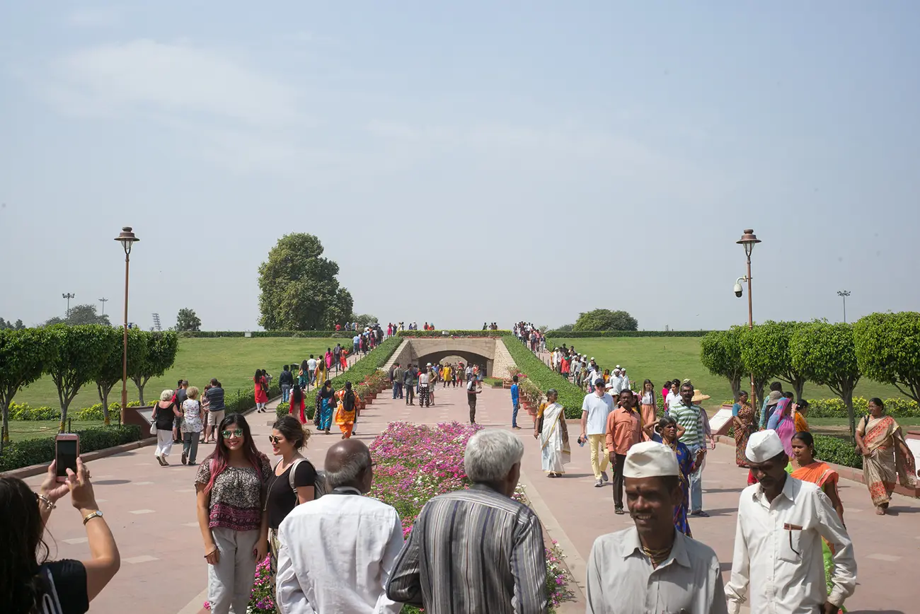
Surrounding the platform is a vast garden with well-kept lawns, flower beds, and shady trees. Fruit trees and seasonal flowers bloom here and are planted to complement the memorial. A stone path leads to the platform, guiding visitors to the center. Tall trees line the park and provide cool shade. Among them are many special trees planted by visiting world leaders.
Each tree has a small plaque naming the dignitary who planted it, symbolizing international respect for Gandhi’s ideals. For example, a Neem tree was planted by Queen Elizabeth II, and President Eisenhower, Ho Chi Minh, and many more planted others. These living memorials add a global dimension to the site. Visitors on guided tours often stroll around these trees, reading the plaques to see which leaders honored Gandhi in this way.
The gardens of Raj Ghat are well-maintained by a dedicated staff. The lawns are mowed and the flowerbeds trimmed with care, a sign of the respect paid to Gandhi’s memory. Along the edges of the garden are simple stone benches where visitors can sit quietly to reflect. The whole area is kept very clean. Even though Delhi’s Ring Road runs nearby, the thick trees and walls help block out most city noise. When you step through Raj Ghat’s gates, the bustle of the capital seems to fade away.
The black platform stands out against the lush green lawn when viewed from a distance. In bright sunlight, the marble gleams, and the flame flickers in the breeze. This contrast of dark stone and bright nature adds to the solemn beauty of the site. Many visitors comment that they hardly notice the busy city around when they enter Raj Ghat’s gardens. As dusk approaches, the sinking sun stretches shadows over the platform, creating a serene and picturesque moment for a visit.
Visitor Experience of Raj Ghat, Delhi
Visiting Raj Ghat is a quiet, thoughtful experience. Many people arrive early in the morning when the soft light and cool air make the memorial look peaceful. Early morning or late afternoon are the best times to visit because Delhi can get hot around noon.
Visitors should note a few rules. Consuming food, beverages, or tobacco is prohibited on the premises. Please keep phones silent or off, and dress modestly (no shorts or sleeveless tops) as a sign of respect.
At the entrance, you will see a small guard booth. Security guards assist visitors and may ask to briefly check bags at the gate (the process is usually quick and polite). Visitors must take off their footwear before entering the memorial space, which has racks provided at the entrance. Removing shoes is a traditional sign of respect. Inside, people stroll up to the black marble platform and stand quietly by the flame. Adults often guide children to speak softly. Many visitors bring flowers or leave marigold petals as a tribute. It is polite to pause or bow for a moment at the platform. Many people also fold their hands and offer a silent prayer here.
Photography is allowed at Raj Ghat (no camera fee). You are welcome to take pictures of the marble platform, the flame, and the gardens. It is best to use natural light and avoid using flash or disturbing others praying or reflecting. A small camera or phone is all you need; large tripods are not required. People often take a few personal photos, but they do so quietly and courteously.
Raj Ghat welcomes visitors daily, typically opening at 5:00 AM and closing at 7:30 PM during summer and opening at 5:30 AM, which is closed at 7:00 PM in winter. There is no admission fee. Because the site is outdoors, time your visit for cooler hours. Plan to spend at least 30–45 minutes here to experience the memorial and stroll the gardens fully. Special events draw larger crowds: every Friday at 4:00 PM, there is a short prayer meeting in Gandhi’s memory, and on his birthday (Oct 2) and death anniversary (Jan 30), large ceremonies are held. These are very respectful occasions, but expect more visitors on those days.
Basic facilities are available near the entrance. You will find drinking water, restrooms, and a small interpretation center with information about Gandhi’s life. Stone benches under trees offer a place to sit. The paths are flat and wide, so the memorial is accessible to people of all ages; visitors in wheelchairs may also enter as long as they remove their shoes.
Many people say they leave Raj Ghat feeling moved. The peaceful atmosphere often stays with visitors long after they go.
Nearby Memorials
Nearby Raj Ghat, there are several other memorials dedicated to India’s leaders, all set in peaceful gardens. Just north of Raj Ghat (about a 5-minute walk) is Shanti Van (also called Shantivan). This is the cremation site of Jawaharlal Nehru, India’s first Prime Minister (died 1964). Its name means “Forest of Peace.” Here, you will find a quiet grove with flowers and pathways to honor Nehru’s memory.
Not far from Raj Ghat (about a 10-minute walk) are the memorials for Indira Gandhi and Rajiv Gandhi, two more leaders of modern India. Shakti Sthal (literally “Place of Strength”) marks where Indira Gandhi was cremated in 1984; it features a tall black stone monument with an eternal flame. Nearby is Veer Bhumi (sometimes called Vir Bhumi, “Land of the Brave”), the memorial for Rajiv Gandhi (he died in 1991). Veer Bhumi has a black marble platform and an eternal flame.
For travelers interested in history, visiting Raj Ghat and these nearby sites together is convenient. Many tour guides recommend walking through the gardens from Raj Ghat up to Shanti Van, then onward to Shakti Sthal and Veer Bhumi. Seeing Gandhi’s memorial with those of Nehru and the Gandhis adds depth to the visit. Some travelers also include the nearby National Gandhi Museum, where personal artifacts and exhibits give further insight into Gandhi’s life. This group of sites makes for a contemplative day of reflection on India’s early leaders.
Why Visit Raj Ghat?
Raj Ghat is more than just a sightseeing stop. It is a place of reflection and meaning. Here, visitors connect with Gandhi’s non-violence, truth, and unity values. Many travelers say that standing at Gandhi’s memorial reminds them of how one person’s beliefs can change a nation. It encourages thoughts about peace, patience, and social change. For those who value history and culture, Raj Ghat provides a quiet moment to think rather than just another tourist photo.
Luxury travelers often appreciate Raj Ghat as a cultural and peaceful interlude in Delhi. It is easy to reach by private car or on a guided tour, and it requires little effort: guests can arrive, remove their shoes, and step into a tranquil space within minutes. Experienced guides can enrich the visit by pointing out features like the trees planted by world leaders or explaining the story of the “He Ram” inscription. Such commentary gives the visit extra depth and context.
The memorial’s simplicity itself is its strength. Unlike grand palaces or busy markets, this site honors humility and history. It shows a different side of India’s capital – quiet respect and remembrance. Even amidst luxury hotels and fine dining, stopping at Raj Ghat adds a meaningful contrast. It reminds travelers that India’s greatness comes from its ideas and values, not just monuments.
Whether or not you consider yourself a history buff, Raj Ghat can be a powerful experience. You don’t have to be an expert on Gandhi to feel the emotion here. Many guests find the memorial unexpectedly moving. It invites everyone, from city explorers to peace seekers, to pause and reflect. In many curated Delhi tours, Raj Ghat becomes a highlight for reflection, not a spectacle. It carries a simple but profound message: take a moment to remember and learn. This way, Raj Ghat adds a meaningful chapter to a traveler’s journey through the capital.
In many travel packages, Raj Ghat serves as a contemplative beginning or end to a day of sightseeing, reminding guests of India’s soul amidst the capital’s bustle. It is a simple yet profound way to connect with the nation’s history and values.
Practical Information
- Location: Raj Ghat is on the western bank of the Yamuna River in New Delhi. It lies along the Ring Road in Old Delhi, about 2 km west of the Red Fort. (Address: Raj Ghat, New Delhi 110002.)
- How to get there: By car or taxi via the Ring Road (the main entrance opens off Mahatma Gandhi Road). Drivers can drop visitors at the gate where shoes are removed. The nearest Delhi Metro stop is Delhi Gate (Violet Line), about a 10-minute walk from Raj Ghat. Auto-rickshaws and buses also serve the area. Luxury tours typically include private car transfers.
- Entry Fee: Free entry. There is no admission or camera fee.
- Photography: Allowed with respect. Visitors often take photos of the marble platform and gardens. Use natural light and avoid flash. Do not disturb others who are praying.
- Facilities: Clean restrooms and drinking water fountains are available. There is a small cafeteria and a souvenir stall on site. An interpretation center provides information about Gandhi’s life. Free parking is provided outside the gates. Stone benches and paved paths are in the gardens for rest and reflection.