Flora of Sagarmatha National Park
Sagarmatha National Park is famous for its towering peaks, including Mount Everest. It also boasts a rich tapestry of plant life that adapts to the park’s varying altitudes. The diverse vegetation zones range from lush rhododendron forests to sparse alpine meadows, each supporting its plant species.
Vegetation Zones in Sagarmatha National Park
The park’s flora varies significantly with elevation, creating distinct ecological zones rich in biodiversity.
- Rhododendron Forests: At lower elevations, the park is home to vibrant rhododendron forests. These forests bloom spectacularly during spring, painting the landscape in vivid red, pink, and white hues. Rhododendrons, Nepal’s national flower, thrive in the moist conditions at these altitudes.
- Alpine Meadows: Higher up in altitude, thick woods turn into mountain meadows. The harsh weather only affords a little protection in these areas. However, they do have a variety of tough grasses and shrubs. Wildflowers can be seen in these meadows for a short time during summer, contrasting with the white caps above them.
Wildflowers, Forests, and Shrubs
The flora in Sagarmatha National Park stands out for its resilience and adaptation to the high-altitude climate.
- Wildflowers: In the summer, the alpine meadows burst into color with wildflowers. Species like edelweiss, blue poppies, and various saxifrages have adapted to the thin air and cold temperatures. These flowers add beauty to the rugged landscape and are crucial for the local ecology, supporting insects and birds.
- Forests: The forests in this National Park are primarily composed of fir, birch, and juniper trees, as well as rhododendrons. These trees are adapted to survive the lower temperatures and moisture levels at higher elevations.
- Shrubs: Juniper is ubiquitous on shrubs and is significant in local traditions and medicine. These bushes and other lower vegetation cover the last green before rocks and ice overwhelm the top altitude.
Mount Everest National Park Significance
Also known as Mount Everest National Park, Sagarmatha National Park stands out for being the entrance to Mount Everest, which is recognized globally. As the highest mountain in the world, it has a significant role in the park. As such, climbers and trekkers flock to this place from every corner of the globe. However, besides its mountaineering significance, it also helps preserve biological diversity and the world’s cultural heritage.
Association with Mount Everest
Imagine Sagarmatha National Park with Mount Everest as its majestic centerpiece. This breathtaking mountain, reaching 8,848 meters, defines the park’s geography and global identity.
- Cultural Symbol: Mount Everest represents more than a mere mountain; it symbolizes human perseverance and adventure. Its towering presence turns the park into a sought-after destination for adventurers and explorers.
- Biodiversity Haven: The region surrounding Mount Everest supports a diverse range of high-altitude plants and wildlife. As a result, this National Park has become a vital sanctuary for preserving unique species and habitats.
Gateway to Everest Base Camp
For trekkers and climbers, Sagarmatha National Park is the starting point for the legendary trek to Everest Base Camp. This trek attracts thousands of visitors annually, eager to experience the stunning Himalayan scenery.
- Trekkers’ Destination: The Everest Base Camp trek ranks as one of the most popular routes worldwide. The Park offers well-established trails, comfortable lodges, and experienced guides for those taking on this adventure.
- Economic Contribution: The constant arrival of trekkers is crucial to enhancing the local economy. The Sherpa communities in the area primarily rely on trekking for their livelihood, which comes from employment opportunities within tourism and hospitality, such as guides or porters.
- Environmental Conservation: The global focus on Mount Everest has also brought attention to the need for conservation. Protecting the fragile Himalayan environment has become a priority, and this National Park is leading these efforts.
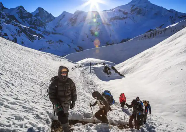
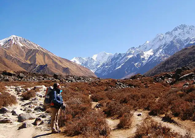
Trekking in Sagarmatha National Park
Sagarmatha National Park, also called Mount Everest National Park, offers some of the most famous trekking routes in the world. Adventurers and nature enthusiasts flock to these challenging trails, eager to explore the park’s stunning landscapes and rich culture. The roads lead trekkers through picturesque Himalayan villages, rugged terrain, and right into the heart of the Himalayas.
Popular Trekking Routes in Sagarmatha National Park
Each trekking route in Sagarmatha National Park presents a distinct experience, combining different difficulty levels with breathtaking scenery.
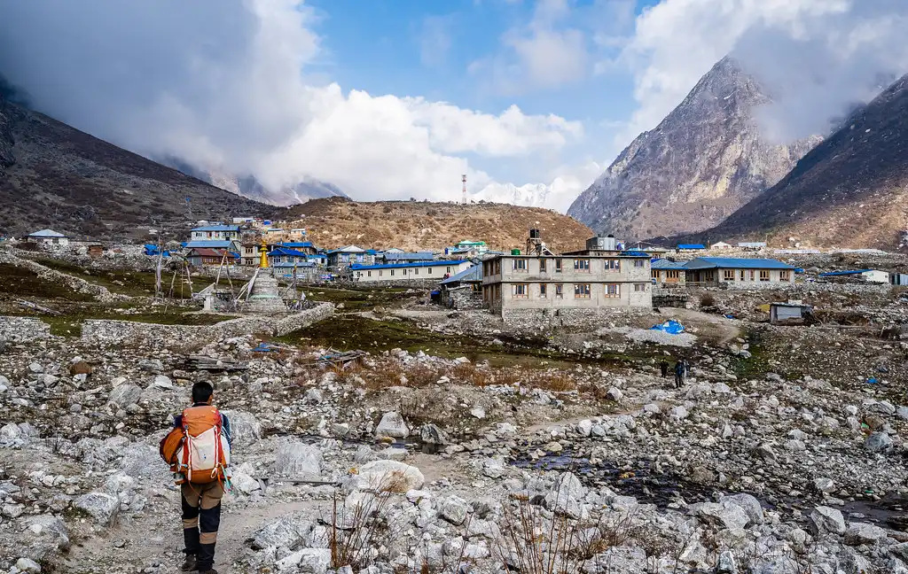
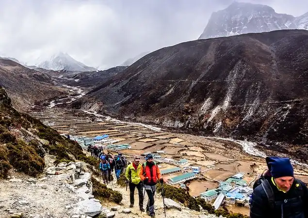
- Everest Base Camp Trek: Thousands of people dream of conquering the Everest Base Camp trek, making it one of the most sought-after hiking experiences globally. It starts from Lukla and lasts approximately two weeks, traveling through Sherpa’s remote territory. Along this route, with overnight stops at Namche Bazaar, Tengboche, or Gorak Shep, hikers can see Mount Everest and several other high-altitude mountains.
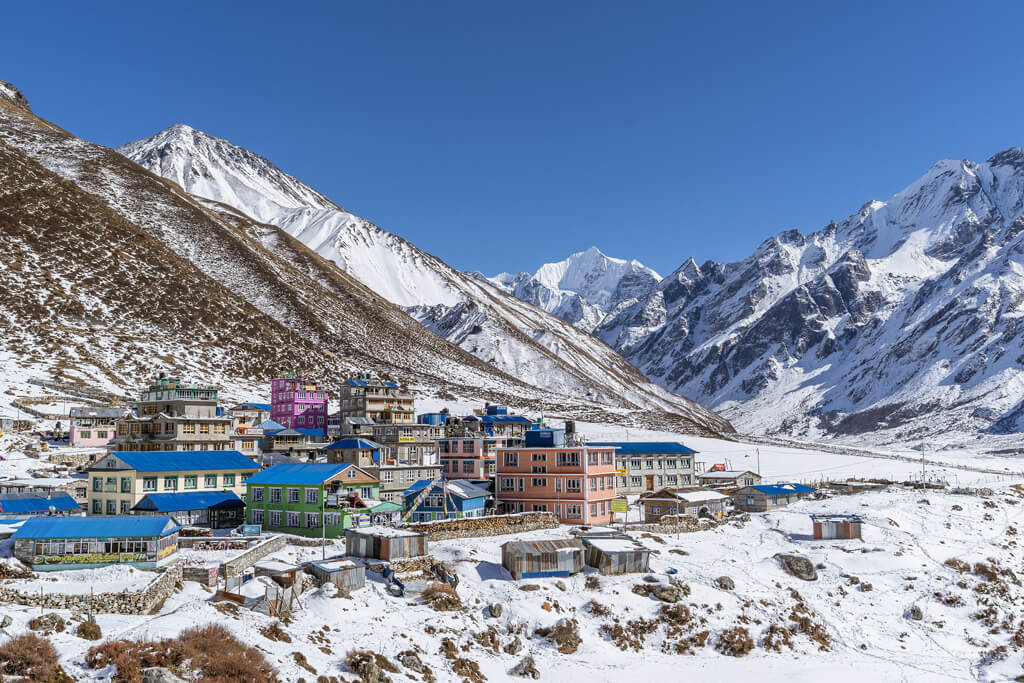
- Gokyo Lakes Trek: For those seeking fewer crowds but equally impressive scenery, the Gokyo Lakes Trek is an ideal alternative. This route leads to six spectacular glacial lakes, offering trekkers serene, panoramic views of the Himalayas.

Gokyo Ri provides a fantastic vantage point from which to see Everest and other majestic peaks. Key stops include Phakding, Namche Bazaar, and Gokyo.
- Three Passes Trek: For thrill-seekers, the Three Passes Trek challenges hikers to cross three high-altitude passes: Kongma La, Cho La, and Renjo La. This route is more demanding but offers unparalleled access to remote valleys and some of the most spectacular views in the region. Essential stops include Namche Bazaar, Lobuche, and Thame.
Important Villages Along the Trekking Routes
Trekking in Sagarmatha National Park offers more than just natural beauty; it allows trekkers to experience the culture of the Sherpa people through stops in several vital villages.
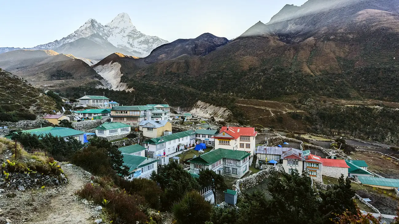
- Namche Bazaar: Known as the gateway to the high Himalayas, Namche Bazaar is a bustling village where trekkers acclimatize before ascending to higher altitudes. The village offers comfortable accommodations, restaurants, and cultural attractions like museums and monasteries.
- Pangboche: Famous for its ancient monastery, Pangboche offers spiritual and scenic allure.
Located along the Everest Base Camp Trek, this village provides spectacular views of Ama Dablam and a peaceful resting point for trekkers.
- Dingboche: Dingboche, often a stop for acclimatization, is surrounded by towering peaks such as Lhotse, Island Peak, and Ama Dablam. The village is a crucial rest point for trekkers attempting the Three Passes Trek or heading towards Everest Base Camp.
Conservation and Environmental Challenges in Sagarmatha National Park
Sagarmatha National Park, renowned as a top trekking destination and vital ecological zone, faces significant environmental challenges. Conservation groups and park management work tirelessly to protect its delicate ecosystems from the impacts of climate change, deforestation, and the pressures of mass tourism.
Protecting Fragile Ecosystems
Ecosystems in Sagarmatha National Park are easily affected. As such, it is home to some of the most unique species of plants and animals that cannot withstand drastic changes in their habitat. There are a few essential issues that may interfere with the ecological balance of the park:
- Climate Change: Rising global temperatures have caused glaciers in Sagarmatha National Park to recede rapidly. This reduction affects freshwater supplies, alters river flow downstream, and disrupts habitats for many species. Ongoing studies aim to understand these effects better and develop solutions to protect the park’s resources.
- Deforestation: Some areas near the edges of the park face deforestation due to the demand for firewood and the need for agricultural land. Conservation efforts focus on promoting sustainable alternatives like solar energy and efficient farming practices to prevent further damage.
- Mass Tourism Impact: Thousands of trekkers visit the park annually, which puts pressure on local resources and increases waste. Managing this influx of visitors is essential to reduce the environmental strain on the park.
Regulations and Measures to Mitigate Environmental Impact
The authorities of Sagarmatha National Park take various vital actions and provide instructions to protect its natural beauty and biodiversity.
- Permit System: All trekkers must obtain permits to enter the park. This system controls the number of visitors and ensures that tourism directly supports conservation efforts.
- Waste Management: Strict rules require trekkers to manage their waste responsibly. Visitors must either carry their trash out or use designated waste disposal sites. Additionally, educational programs promote the “leave no trace” philosophy to maintain the park’s cleanliness.
- Eco-friendly Lodges: Lodges and facilities within Sagarmatha National Park are required to follow eco-friendly practices. Many use solar energy and water conservation techniques to reduce their environmental footprint. Sustainable waste management systems are also in place to handle the growing number of visitors.
- Conservation Initiatives: International collaborations help run various conservation programs focusing on habitat restoration, protecting endangered species, and building resilience against climate change in Sagarmatha National Park.
Visitor Information for Sagarmatha National Park
Exploring Sagarmatha National Park promises an exciting and unforgettable adventure. Often referred to as Mount Everest National Park, this area draws trekkers, nature enthusiasts, and adventurers worldwide. To ensure you have a safe and enjoyable experience, knowing it’s the best time to visit, understanding the permit requirements, and preparing for accommodation, food, and essential trekking gear is crucial.
Best Times to Visit Sagarmatha National Park
- Optimal Seasons: If you want to experience this National Park at its best, go there between March and May or from September to November. During these months, the weather is suitable for trekking, with stable temperatures and clear skies that are good for taking photos or going on high-altitude treks.
- Off-Peak Seasons: Visiting outside these peak seasons can mean fewer crowds but less predictable weather. From June to August, the monsoon season brings heavy rains, which may cause landslides and make trekking trails challenging.
Sagarmatha National Park Permit Requirements
- Entry Permit: All visitors must obtain a Sagarmatha National Park entry permit to access the park. You can get this permit in Kathmandu or at the Monjo Visitor Center, which lies on the route to Everest Base Camp.
- Regulations: Trekkers must follow park regulations to protect the environment, including guidelines for waste disposal and restrictions on hiking off established trails. These rules ensure that this National Park remains a pristine natural habitat for future visitors.
Tips for Accommodation, Food, and Essential Gear
Accommodation: There are diverse forms of lodging available at the park, ranging from basic teahouses to more luxurious lodges. It is advisable to book such accommodations in advance during busy trekking periods for guaranteed occupancy.
Food: Teahouses and lodges in Sagarmatha National Park serve meals ideal for trekking, focusing on providing energy-rich foods like carbohydrates and proteins. It’s also a good idea to bring some high-energy snacks, as food options become more limited at higher altitudes.
Essential Gear: Having the right gear is critical to make your trekking experience more enjoyable.
- Sturdy hiking boots: Ensure your shoes are well broken in to prevent blisters and discomfort.
- Layered clothing: Temperatures in the park vary significantly, so wearing layers will keep you comfortable day and night.
- Navigation tools: Whether it’s maps or a GPS device, having navigation tools will help you stay on track, especially in less-traveled areas.
- Sleeping bag: Even though many lodges provide bedding, having your sleeping bag ensures warmth in cold mountain conditions.
- Water purification system: Carrying a water purification system tablet or a portable filter is essential for staying hydrated while trekking.
Conclusion
Sagarmatha National Park is a remarkable blend of natural beauty and cultural heritage, offering breathtaking landscapes and rich biodiversity. Its towering peaks, most notably Mount Everest, attract adventurers worldwide. The Park protects endangered species like the snow leopard and Himalayan tahr, making it a critical conservation area. With its diverse wildlife, including many Sagarmatha National Park animals, and its stunning vistas, this park remains a top destination for nature enthusiasts and trekkers.
Sagarmatha National Park holds profound cultural importance in addition to its environmental significance. The Sherpa community enhances the experience for tourists by having spiritual ties with Mount Everest. While trekking through this beautiful landscape, one will also walk on a land with history and culture.